During the 1950s, the U.S. government detonated 928 nuclear weapons at its Nevada proving grounds, just 65 miles northwest of Las Vegas. The chamber of commerce published detonation schedules for tourists, and casinos cashed in with boozy “atomic parties” that ended with a viewing of the world’s biggest bang.
It’s ironic, given that a direct nuclear strike could only improve the Las Vegas strip. But what the city lacks in charm and soul, it makes up for in geography. Look beyond the blasted deserts of Vegas Valley and you’ll find some of the most spectacular landscapes in North America.
Our exploration of the Southwest began with Eagle Rider, the largest motorcycle tour company in the U.S. Knowing I’d be in Las Vegas for a conference, I booked a nine-day “self drive” tour that would take my wife Lana and me through some of the region’s most famous parks and national monuments. No tour groups, no follow-the-leader formation rides; Eagle Rider would provide the bike and a road book, and book our accommodations. The rest would be up to us.
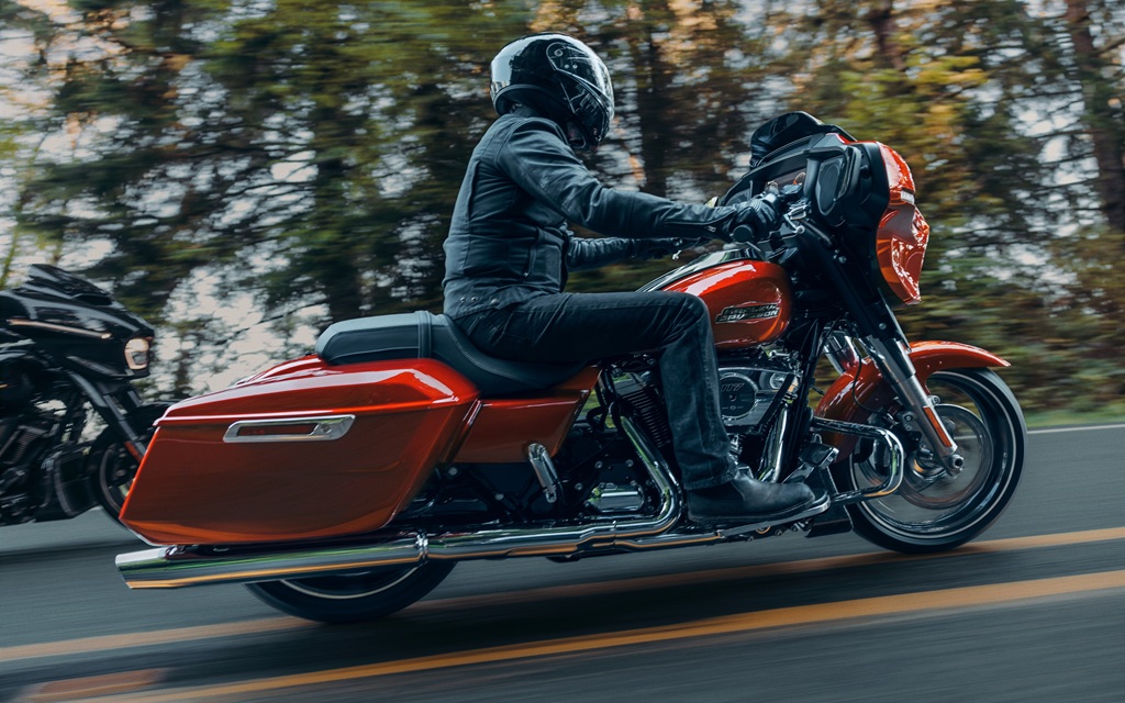
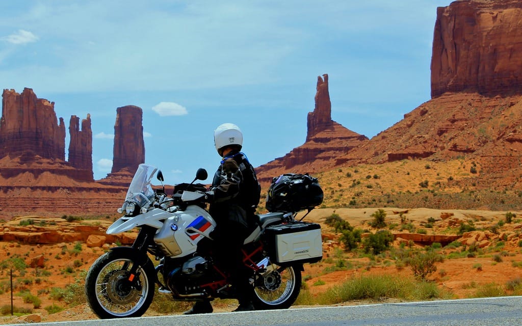
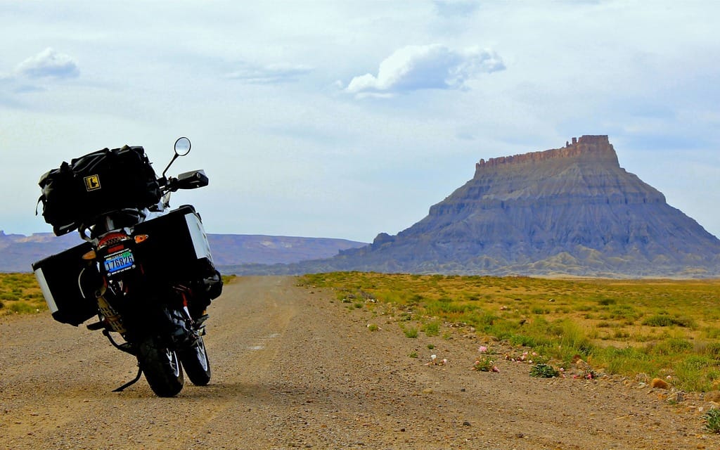
After a few days of $30 burgers and $20 cocktails, we pick up our new ride from Las Vegas BMW: a well-kept 2013 BMW R1200GS in smart white, red and blue “Rallye” colours. We thread our way through afternoon traffic, heading southeast via the Hoover Dam to Kingman, Arizona, and the best-preserved stretch of historic Route 66.
About a half hour outside of Kingman, a series of handmade signs draws me off the highway and five miles down a side road to a place called Chloride. Once a busy hub for silver mines in the surrounding Cerbat Mountains, Chloride is now mostly a ghost town, home to a handful of artists, hermits, retirees and a few families who like desert skies and peace and quiet. Sculptures made of rusting mining equipment fill front yards. Some of the old buildings are well preserved, including the two-room jail and the oldest post office in Arizona. If you’re up for the challenge, a 30-minute ride down a rutted, sandy road will take you to a series of huge outdoor murals painted on boulders by the western artist Roy Purcell. Two-up and fully loaded with gear, we opt instead for Kingman, a hotel, and a dip in a cool swimming pool.
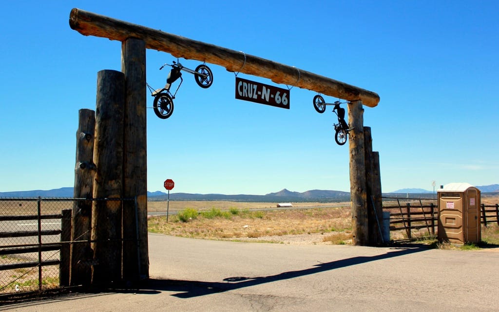
The next morning the Mother Road takes us east, through a wide-open plain. Scrub-laced hills rise up from fields of chaparral almost as parched as my mouth. The cross wind is fierce, so a rest stop called Cruz-N-66 provides a welcome opportunity for a break. We eat some jerky, pet a couple of bored-looking burros in a corral, and gawk at the scenery. The back 40 of Cruz-N-66 looks to be about 40 miles deep. There’s nothing out there but wind and mountains.
Following 66 leads us through Seligman to Peach Springs. We stop for a tour of the Grand Canyon Caverns, the largest dry cavern system in the U.S. It’s a tourist trap, but I can’t help but be impressed by the ingenuity of the owners. They’ve installed a hotel room in the cavern, 220 feet below the ground. There are comfortable beds, a TV and DVDs, and board games. When you turn in for the night, the darkness and silence is complete. Nothing can live in the cave — not even bacteria. To prove the point, the owners have put on display a dried-up bobcat that fell into the cave and broke its leg 164 years ago. There’s not much meat left on him, but the skin, fur, and teeth are intact.
We head south, then east, into the Prescott National Forest. It’s been a while since I’ve ridden in the mountains, and this road is tight. At times I can feel Lana grow tense as sharp curves reveal 500-foot drop-offs. The road is a thrill to ride, but I can’t testify to whether it’s scenic or not. All my attention is focused on what’s ahead of me.
The countless hairpins end abruptly in Jerome, an old copper-mining camp perched on the side of the mountain. We’re instantly charmed by the place. At one time the fourth largest town in Arizona, Jerome was largely abandoned after the closing of the Phelps Dodge Mine in 1953. Today, it’s home to a few hundred artists and B&B operators, who have lovingly restored the town’s old buildings. Jerome sits perched on a 30-degree incline, offering stunning views into the Verde Valley thousands of feet below. Stop for lunch on the patio at the Haunted Hamburger, and you can see clear across the valley to the red rocks of Sedona.
We bunk in Sedona, but since we don’t play golf or believe in the healing power of crystals, we leave first thing in the morning and head towards the Grand Canyon. Approaching from the south, there are two possible routes for visiting the canyon. If you’re comfortable on rough dirt roads and have plenty of cash, you can drive north of Kingman to the Hualapai reservation, and Grand Canyon west. This is where you’ll find the Grand Canyon skywalk, a transparent, horseshoe-shaped observation platform that juts out into space above the Canyon floor. Expect to pay upwards of $80 for the experience.
Like most people, we opt for the south rim. I expect to go elbow-to-elbow with hordes of bus tourists, but the Canyon is surprisingly quiet. We leave the bike and trot to the viewpoint behind the visitors’ centre, eager for our first look at the Canyon. I’m stopped in my tracks. We stand in silence, peering down into this secret world of rippled rock, pinyon pine, and hidden river oases.
The next morning we motor east, stopping at Grandview and Lipan Points, then Desert View, the last and most magnificent viewpoint on the South Rim. From here you have an eagle’s view of some of the park’s mightiest rock formations: Wotan’s Throne, Cape Royal, and Palisades of the Desert. The Desert View watchtower stands here, the work of American architect Mary Colter. A recreation of Anasazi Indian towers found in other parts of the Southwest, it serves as a reminder that native peoples have inhabited the Grand Canyon for more than 12,000 years.
Just east of the Grand Canyon National Park lies the Navajo Nation, the largest Native American reservation in the United States. Home to more than 200,000 Navajos, the reservation covers 27,000 square miles, making it larger than the state of West Virginia. To the Navajo, who call themselves the Diné (“the people”), this land is known as the Diné tah.
Our primary reason for entering the Diné tah is to visit Monument Valley. The foreboding sandstone buttes most of us associate with cowboy movies — Stagecoach, The Searchers, My Darling Clementine — are still owned and controlled by the Navajo people. Following the advice of another motorcyclist, we leave the bike at our hotel and hire a Navajo guide for a semi-private tour. Leo Sam picks us up in his dusty GMC Suburban, along with our tour mates, Dick and Rhoda, a pair of spunky octogenarians from Indianapolis.
As we make our way down into the valley proper, I realize that riding here would have been a very bad idea. The road is an undulating mix of steep, rocky hills and sandy washes. It would have been a nightmare on the big GS. So I sit back, relax, and let Leo do the driving and the talking. He’s a soft-spoken man, and a thoughtful one. At first I think he’s hard of hearing, but then I realize he takes a few moments to think about his responses to each of our questions.
Leo points out the most famous buttes, stone monoliths whipped by wind and sand into fantastical shapes. Compared to the majestic names of their counterparts in the Grand Canyon, the names of buttes seem oddly prosaic: the Mittens, the Thumb, Elephant Butte, Submarine Butte. Although Sleeping Dragon Butte really does resemble a Godzilla-like creature, stretched in a doze across the Valley floor.
As he drives, Leo tells us stories about his culture, and about the Anasazi, the ancient and culturally advanced race of Pueblo Indians who mysteriously disappeared from the Southwest 1,000 years ago. Navajos treat Anasazi relics with great respect, believing that disturbing the ghosts of those long-ago people can cause sickness. Leo brings us to a rock wall to view some Anasazi pictograms. There are others in the park, he says, that include drawings of beings resembling aliens.
The place is uncannily quiet. We haven’t seen any other tourists in some time, and it feels like we’re totally alone in this wild, vast place. Something in the shape of this rock wall projects echoes through the valley, compounding our sense of isolation. Leo offers to sing us a song from his culture, which he translates as “Beauty, Come to Me.” As he sings, the sunset purples the overhanging clouds, and a few errant rays of light splash gold across the faces of the tallest buttes and rock spires. The echoes lift Leo’s voice up out of the Valley, like smoke from a fire.
Time to turn north, towards the crown jewels of Utah’s national parks: Bryce Canyon and Zion. We leave the Navajo lands behind at Mexican Hat, and follow US State Route 261 through the Valley of the Gods, a lonely landscape of mesas and buttes. Suddenly the road signs take on an ominous tone: 10 percent grades; 5 mph switchbacks; narrow gravel road. I backtrack, thinking we had somehow veered off our route. Nope. As we discover, this is the Moki Dugway, an infamous mining company road that climbs the face of Cedar Mesa. We begin our ascent, hoping the views will distract us from the absence of guardrails. The Dugway proves tamer than we had feared; it’s certainly steep, but the gravel is well graded and the corners of the switchbacks are paved. In three miles we rise 1,200 feet to the top of Cedar Mesa. After each corner I find myself laughing in my helmet at the dazzling views. When we reach the top, we can see clear back to Monument Valley, the Mitten buttes saluting us from more than 40 miles away.
We leave 261 and turn north on UT-95, part of a scenic byway called the Trail of the Ancients. The road takes us through moonscape deserts, up across high desert plateaus capped with snow-dusted mountains, down to the Colorado River and back up again. It’s starkly beautiful, and virtually empty of people. At some point on this road, I began to regret not gassing up in Mexican Hat. The prevailing head wind is affecting our fuel consumption. I stop at the next likely place on the map, a lodge that’s supposed to carry gas. But the place is closed, and the no-trespassing signs are peppered with bullet holes. The next major town, Hanksville, is 60 miles away, and we’re down to 62 miles of range. Half an hour later, I spy a sign for a marina on nearby Lake Powell. It’s five miles down a side road, which means if they have no gas, we’re in trouble. We take the risk, sighing with relief when we find the fuel pumps open for business.
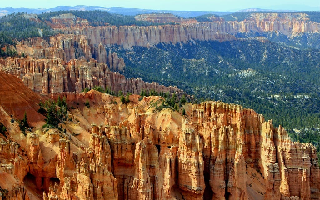
After a night in Torrey, we follow Scenic Route 12 as it skips and tumbles south through Capital Reef Park to Bryce Canyon. This is one of the best motorcycle roads in the area, 124 miles of curving blacktop that runs through alpine forests, sagebrush flats and clusters of pink and russet stone turrets. Bryce Canyon itself is a marvel, a massive amphitheatre filled with spiky hoodoos and garlanded with ponderosa pine. But down the road is an even nicer surprise: Cedar Breaks National Monument. The road takes us more than 10,000 feet up through a Siberian landscape of snow and birch forest. The canyon here is a smaller-scale version of Bryce, and we have it all to ourselves.
There is a massive crush of tourists at Bryce Canyon Village, which is odd because the park didn’t seem all that busy. The Syrett family has had a lock on this location since 1916, when Reuben C. “Ruby” Syrett built a tourist lodge on the lip of the Canyon. “Ruby’s” is now a multi-million dollar complex of hotels and restaurants, catering primarily to European tourists. Lana and I join 500 visitors from France at Ruby’s Wild West dinner show. At dinner, I help a puzzled-looking Parisian navigate the buffet. I point to one tray and say, “cowboy beans.” He nods in understanding and smiles. “Ah, oui, les haricots cowboy. Yee haw!”
One more stop, one more taste of the glories of the American Southwest before a return to Las Vegas, and home. We think we’ve left the best for last: Zion National Park. Located at the intersection of the Colorado Plateau, Great Basin and Mojave Desert regions, it’s Utah’s oldest and most popular park, a wonderland of mountains and slot canyons, rivers and arches, mesas and buttes.
We enter the park from the east side and the road plunges us into the total blackness of a mile-long tunnel. We pop out the other side into a primeval lost world, surrounded on all sides by towering sandstone walls. We corkscrew down and down into the Virgin River valley, but we’re soon forced to head south and out of the park. The Zion Scenic Road that runs north is only accessible by shuttlebus during the high season. Total elapsed time in Zion National Park: 90 minutes.
Then we remember some advice given to us by a couple from California: take Kolob Terrace Road. Paved but sparsely maintained, Kolob Terrace accesses the little-travelled western end of Zion. We pick up the road at the town of Virgin and head north. It’s barely two lanes wide, traversing open ranchland before snaking its way to higher elevations. When we re-enter the park, the pavement abruptly turns to ochre. We travel through stands of dead trees, past mesas, walls and cliffs of wind-warped sandstone, and up 5 mph switchbacks. We stop for a rest by an endless field of tall green grasses. The grasses sway in the breeze, sending waves rushing toward the mountain peaks on the horizon. There are no fences or houses to impede their progress. Only wind, and sky, and rock, and grass. Like it always has been. Like it always will be. I hope.